Showing posts with label weather. Show all posts

Monday, May 23, 2011

Storm, 5/23/2011


Two summers ago, I found myself caught in a spooky pre-tornadic storm as I made my way East on Shelbyville Road and then moved sideward to Westport. It happened all over again today.


Photographs rarely convey just how creepy some storms can be; though these examples aren't as dramatic looking as some of my other storm images, the knowledge that this was part of the same weather system that destroyed Joplin, MO gave me extra incentive to hustle home ASAP.

Tuesday, May 3, 2011

Latest Kentucky Floods of 2011


While the world watches and waits to see what further ill effects may occur from the Destruction of the Birds Point Levee, the storm fronts keeps moving in, rain keeps coming down, and flood waters keep rising like in the old Johnny Cash song.

Union County is essentially closed off and surrounded by high water now. According to the Henderson Gleaner, Union County schools and postal services are almost completely out. The Union post office has had to make an emergency relocation to nearby Henderson County.

Livingston County is under emergency evacuation as I type this. The evacuations in Smithland are mandatory and police-enforced, while residents of the towns of Iuke, Ledbetter, and Tiline are also being urged to evacuate for their own safety at this hour. Kentucky State Police have set up a temporary command post at Grand Rivers, and will be organizing all Fire, ambulance, and rescue operations from here.

In Fulton County, many worried citizens have been fleeing Hickman. Gov. Beshear has been monitoring the area in person, and said on Tuesday that blowing up the levee in Missouri was the right decision, because it's helping to take the pressure off Kentucky's own floodwalls.

In McCracken County, The Republic is reporting "The National Weather Service in Paducah forecast a crest of 55 feet, or 3 feet above flood stage, on the Ohio River in Paducah".

Kenton County was declared a disaster area last week when floodwaters closed a dozen roads and tornadoes ripped through the area. They, along with most of Northern Kentucky, are listed on today's flood advisory again as I type this.

Calloway County was, according to thenews.org, under a flood warning until this morning, and it will still take a lot of time for the water to go down. There is water over many roads, although none are closed down at this time.

In Jefferson County, flood waters crossed River Road and lapped at the edges of the Yum! Center and at Butchertown's flood walls. Today the water levels of the Ohio River are receding, but heavy rain is expected in the forecast and it remains to be seen whether the flooding here is truly over.

Thursday, April 21, 2011

Fallen Trees and Flooded Streams


Last night's storm (it's still last night to me even though this post is dated Thursday because I'm typing it at just a few minutes after midnight, see) was something, wasn't it? Me and Krampus were holed up here on the old JSH Plantation, listening to the hurricane-force winds and emergency sirens, getting ready to take shelter in the center of the house if need be. I spent a couple hours bouncing public and private messages back and forth on Twitter with various peeps-o-mine, which kept my mind occupied until the storm abated enough that I finally fell asleep around 3am.

This morning (Wednesday morning) when I got up, I found that Anchorage had become a landscape of devastated trees - including one that fell on my car and gave it some minor dents and scuffs. Could have been a lot worse, it's obvious to see.


Additionally, the creek is now swollen so far over its banks that vast areas of the nearby park are totally flooded. Between the fallen trees and flood waters, some of the trails are completely impassable now.


Monday, April 4, 2011

Storm, 4/4/2011


Was out wandering in the woods again this morning and a storm started blowing in.

I thought I'd better skidoo since I'd heard reports of the potential for tornadic weather; plus I knew storms and high winds during the night had already knocked out power in parts of downtown and Butchertown.

But I scurried home for nothing - the storm was extremely fast-moving and the dark clouds had already vamoosed to Owsley County by the time I made it back to my car. It's still super-windy out there at the moment, though, so we're not out of the woods yet. So to speak.

Wednesday, March 9, 2011

Kentucky's Deadliest Tornadoes


Since we're not in the tornado-heavy plains states, some might find it rather surprising that Kentucky has placed two entries in NOAA's top 25 deadliest tornado systems in U.S. history.

We bottom the list and then top it: Kentucky squeaks in at #25 with Louisville's tornado outbreak of March 27, 1890. This tornado family spawned at least 24 tornadoes that killed 76 people and destroyed 766 buildings between Parkland and Crescent Hill.

Falls City Hall on Louisville's Market Street was destroyed in the storm, killing at least 55 people by one source's tally but around 200 by another. This also has the distinction, by some estimates, of being the highest death toll due to a single building collapse from a tornado in America. Historian Bryan S. Bush writes:

"Most of the lives lost occurred at the Falls City Hall, located on Market Street, within five minutes the building collapsed with two hundred victims trapped in the rubble. Several activities occurred when the tornado hit the building. The Falls City Hall had a dancing class, which took place on the second floor, with sixty mothers and small girls occupying the class. Only twelve escaped the carnage. In another room the Roman Knights held their meeting, in which seven members were present, the Knights lost one man. On the third floor, the Knights and Ladies of Honor held a meeting with 150 members present, but only a few escaped. The Ancient Order of Foresters had eighteen members present in another room, with all members lost."


And if you've ever wondered what the heck this less-than-impressive minimalist sculpture is (see image below) in downtown Louisville, now you know: it's a monument to the 1890 disaster.


Kentucky was also involved in the #1 tornado, which is generally called the "Tri-State Tornado of 1925" but actually struck more than three states: Missouri, Illinois, Indiana, Kentucky, Tennessee, Alabama, Kansas, and possibly other states were hit by this storm system on March 18, 1925.

Louisville wasn't the only part of Kentucky affected by this group of tornados: at least three people died in Pewee Valley; 39 died in an F4 that swept away farms and homes across Allen, Barren, Monroe, and Metcalfe counties; and an F3 passed throgh Marion, Washington, Bourbon, Mercer, Jessamine, and Fayette counties, killing two and injuring 40 before it finally sputtered out near Lexington.

Southern Indiana was also badly ravaged by the twisters. The town of Griffin was nearly completely wiped off the map, and the town of Elizabeth suffered devastation of several farms.
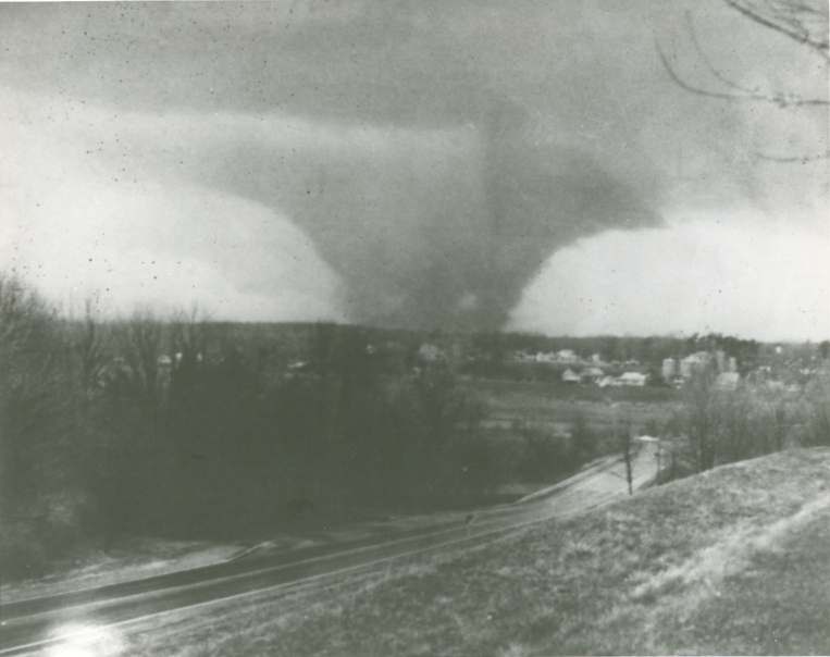

I'm puzzled why the Super Outbreak of April 1974 didn't make NOAA's top 25 charts, because by all accounts 330 people were killed from a series of 148 twisters in 24 hours. Can someone explain this omission to me?

Apparently NOAA is choosing to count each of these tornados as a stand-alone event rather than grouping them all together, yet it is by grouping twisters together that they arrive at the aforementioned "Tri-State" event and the 1890 one.

The photo below shows a tornado from the Super Outbreak approaching Richmond, from Mike Schwendeman by way of april31974.com.

Wednesday, October 27, 2010

Post-Tornado Rainbow


Yesterday I thought it was just a typical windy Autumn morning while I was sitting in the Middletown Starbucks. What I didn't know was that most of Kentucky was on a tornado watch, that a tornado had been spotted just over the river in Indiana, and another one had overturned a semi-truck on the Watterson.

Meanwhile, in Scott County, a forming funnel cloud was caught on video, and in Hopkinsville, one tore the roof off a storage building. That may or may not be the same one witnessed by National Weather Service spotters near Pembroke, and then in Dunmor in Muhlenberg County. An enormous tree in Berea toppled in the storm, narrowly missing an entire apartment complex. In Middlesboro, the mall was damaged and the power was knocked out.

To my surprise, one of the baristas came to the center of the room and announced, "uh, everybody, your attention please, we've just been informed that funnel clouds have been seen in Anchorage, so I'm going to have to ask you all to move away from the glass windows and to the rear of the building, for your safety."

And so we all migrated to the back, everyone suddenly intently tapping at their laptops and handhelds, and within seconds, we were all sharing info with each other that we'd gleaned. One guy instantly had a real-time animation from the NWS on his laptop full-screen, and was showing us how it was estimated to be moving at 80MPH and thus would be past us very quickly. It wasn't that long ago that we'd all be huddled around a radio, listening for the latest wire-service news update from the DJ, but now, every citizen with wi-fi internet access is instantly better informed than even that radio DJ of yesteryear.

Though the tornadic front did indeed swiftly pass, the rainstorm on its coattails continued for hours more. But when it was over and blue sky began to peek out from the cloud cover, I caught an odd rainbow that only existed over a portion of very specific clouds - when those clouds shifted, so did the rainbow, and when that cloud system rolled away, the rainbow was gone. Though my eye saw an evenly ordered full spectrum in it, my camera surprisingly did not - at least, not as clearly.


Sunday, August 1, 2010

Storm Over Stonehenge


I never get bored with storm pictures. Took these a few weeks ago during a really bad storm as I drove down Louisville's Shelbyville Road and could feel the temperature and the barometric pressure suddenly plummet. We didn't get a tornado that day, but I think we really dodged the bullet.


Tuesday, May 4, 2010

Riptide Under Water


More flood images: our friend Dan Brandenburg just emailed these photos of the Riptide On The River restaurant and bar, half-submerged by this past weekend's floods. Here's hoping they get back up and running soon, because I wanna linger in their Tiki Bar this summer!


Monday, May 3, 2010

Beargrass Creek Flood


Severe flooding hit the Old Cannons/Seneca Park area along Louisville's Beargrass Creek this past weekend, leaving many sections of road impassable.

Wednesday, December 23, 2009

Waterspout in Kentucky?


This puzzling datum is from the New York Times, August 24, 1901.

A waterspout on a creek? Seriously? Is that possible? A waterspout is, by definition, a funnel cloud that connects from a cumuliform cloud to a large body of water, usually the ocean or the Great Lakes.

Wednesday, August 5, 2009

Lost in the Flood


Après nous, le Déluge. Tuesday morning I was dashing out in the torrential thunderstorm, on the way to a meeting at Starbucks on Blankenbaker. I witnessed lightning striking a tree across the street, sending branches flying. That should have been a warning sign to forget the meeting and go back inside, but I stubbornly pressed on.

Unfortunately, my car has developed an aversion to rain - something's getting wet under the hood (starter? battery? distributor cap?) and makes it reluctant to run under moist conditions. It died right around a sharp curve on Watterson Trail, and wouldn't start again. A couple of cars came speeding around the corner and very nearly slamming into me since visibility in the downpour was very low. Finally I had to put it in neutral and push it out of the road. About half an hour later, I was able to get it started again.

Unbeknownst to me at the time, a lot of other people in Louisville were having far worse troubles. From WAVE-TV:


In Louisville, there's flooding at Second and Broadway, and First and Main. East Breckenridge Street also has water as high as car windows.

Police had to pull a driver from a vehicle at Grinstead and Cherokee Road, and there was another rescue at 15th and Hill Street.

In New Albany, cars were floating in high water at Scribner Place and Thomas.

There were reports of three feet of water at Arthur Street and Eastern Parkway. And someone reported seeing a person floating in a motorized wheelchair at 901 south 15th Street.

There are also unconfirmed reports that manhole covers are blowing off because of the heavy rain.

Norton Hospital on disaster due to flood damage.


And from bizjournals.com:

One of the hardest hit public buildings was the main branch of the Louisville Free Public Library, 301 York St.

Craig Buthod, executive director of the library system, said that the lower level of the library building took on several feet of water. He estimated that “tens of thousands” of books were lost.

Buthod said that the building’s heating, ventilation and air conditioning system was under water, as was his personal car, library vehicles and Bookmobile units.

The library is expected to be closed through at least Wednesday.


And most tragic of all, from WHAS-TV:

Witnesses say it took only minutes for floodwaters to rise nearly waist deep inside Louisville’s animal shelter.

But with only a dozen people around and nearly 600 animals, they couldn't get them all to safety in time.

One dog and nearly a dozen cats drowned Tuesday afternoon.


(Photos by Kari Donahue.)

Friday, June 12, 2009

Storm, 6-11-09


A few hours ago I was stuck in a very bad storm in St. Matthews, surrounded by extremely low-hanging dark clouds with little pendulous whatchamacallits that wobbled threateningly, looking as if they could form into tornadoes at any moment. The winds at several points seemed near-tornadic, whipping rain and debris around into spirals, and shaking my car violently.


And of course, like some dopey Weather Channel storm-chaser, I'm following 'em and taking pictures, hoping to catch some cool funnel cloud photos.

No such luck.